


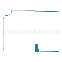
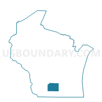
RUTLAND - T 2 Voting District, Dane County, Wisconsin
About
Outline

Summary
| Unique Area Identifier | 693177 |
| Name | RUTLAND - T 2 Voting District |
| County | Dane County |
| State | Wisconsin |
| Area (square miles) | 15.16 |
| Land Area (square miles) | 15.04 |
| Water Area (square miles) | 0.12 |
| % of Land Area | 99.24 |
| % of Water Area | 0.76 |
| Latitude of the Internal Point | 42.88669800 |
| Longtitude of the Internal Point | -89.34123740 |
Maps

Graphs
Select a template below for downloading or customizing gragh for RUTLAND - T 2 Voting District, Dane County, Wisconsin


Neighbors
Neighoring Voting District (by Name) Neighboring Voting District on the Map
- Brooklyn - V 2 Voting District, Dane County, WI
- DUNN - T 5 Voting District, Dane County, WI
- OREGON - T 1 Voting District, Dane County, WI
- Oregon - V 2 Voting District, Dane County, WI
- Oregon - V 3 Voting District, Dane County, WI
- Oregon - V 4 Voting District, Dane County, WI
- RUTLAND - T 1 Voting District, Dane County, WI
- UNION - T 1 Voting District, Rock County, WI
Top 10 Neighboring County Subdivision (by Population) Neighboring County Subdivision on the Map
- Oregon village, Dane County, WI (9,231)
- Dunn town, Dane County, WI (4,931)
- Oregon town, Dane County, WI (3,184)
- Union town, Rock County, WI (2,099)
- Rutland town, Dane County, WI (1,966)
- Brooklyn village, Dane County, WI (936)
Top 10 Neighboring Place (by Population) Neighboring Place on the Map
Top 10 Neighboring Unified School District (by Population) Neighboring Unified School District on the Map
- Stoughton Area School District, WI (20,696)
- Oregon School District, WI (19,594)
- Evansville Community School District, WI (9,234)
Top 10 Neighboring State Legislative District Lower Chamber (by Population) Neighboring State Legislative District Lower Chamber on the Map
- Assembly District 46, WI (65,837)
- Assembly District 48, WI (61,402)
- Assembly District 80, WI (60,352)
Top 10 Neighboring State Legislative District Upper Chamber (by Population) Neighboring State Legislative District Upper Chamber on the Map
Top 10 Neighboring 111th Congressional District (by Population) Neighboring 111th Congressional District on the Map
Top 10 Neighboring Census Tract (by Population) Neighboring Census Tract on the Map
- Census Tract 29, Rock County, WI (8,058)
- Census Tract 125.01, Dane County, WI (6,551)
- Census Tract 106, Dane County, WI (5,141)
- Census Tract 124, Dane County, WI (4,805)